Our ability to get on an Interstate Highway and drive across the country is something we take for granted, but it is one of the most important public work achievements in the history of the U.S. The National Interstate and Defense Highway Act was signed by President Dwight D. Eisenhower on June 26, 1956. The bill created a 41,000-mile “National System of Interstate and Defense Highways” that would change the way people traveled across our country.
According to History.com, “Today, there are more than 250 million cars and trucks in the United States, or almost one per person. At the end of the 19th century, by contrast, there was just one motorized vehicle on the road for every 18,000 Americans. At the same time, most of those roads were made not of asphalt or concrete but of packed dirt (on good days) or mud. Under these circumstances, driving a motorcar was not simply a way to get from one place to another: It was an adventure. Outside cities and towns, there were almost no gas stations or even street signs, and rest stops were unheard-of. “Automobiling,” said the Brooklyn Eagle newspaper in 1910, was “the last call of the wild.”
By the early 20th century, the disorganized infrastructure of the country had 2-lane routes which were not connected in a rational and efficient system. It became an important issue for Eisenhower, beginning with what he experienced in the military, first as a young Lieutenant Colonel in 1919 when he participated in the first Army Transcontinental Motor Convey. According to www.eisenhower.archives.gov, “The expedition consisted of eighty-one motorized Army vehicles that crossed the United States from Washington, D.C. to San Francisco, a venture covering a distance of 3,251 miles in 62 days. The expedition was manned by 24 officers and 258 enlisted men. The convoy was to test the mobility of the military during wartime conditions. As an observer for the War Department, Lt. Col. Eisenhower learned first-hand of the difficulties faced in traveling great distances on roads that were impassable, and that resulted in frequent breakdowns of the military vehicles. These early experiences influenced his later decisions concerning the building of the interstate highway system during his presidential administration.”
Another strong influence that shaped Eisenhower’s view on the importance of a super highway happened when he was stationed in Germany as Supreme Commander of the Allied forces during World War II. He was impressed with the country’s Autobahn, a high-speed freeway system that provided easy transport for military supplies and troop deployments.
When Eisenhower became president in 1953, tensions with Russia were increasing into what became known as the Cold War, and threat of nuclear attack was considered very real. The ability to move troops and equipment quickly across the country gained importance as an efficient infrastructure. He also felt it made travel faster, easier, and safer for the public, while uniting cities across the country with proper access.
As President Dwight D. Eisenhower began to promote creation of a program to build the Interstate Construction Program, the Nation’s Governors made clear to him that they did not want to be forced to increase State taxes to pay the additional matching funds for the national program. Therefore, the President proposed to increase funds for the Interstate System, while boosting the Federal share to 90 percent. Under his proposal, the States would continue paying the same amount in matching funds for the Interstate System that they had been paying.
When the program took shape in the Federal-Aid Highway Act of 1956, it differed in some ways from the President’s proposal, particularly with regard to the source of funding for the program, but Congress retained the Federal-State matching share of 90-10 as a reflection of the Interstate Construction Program’s importance to national goals. (In the western States with large amounts of untaxed public land, the Federal share could be increased to 95 percent.) In all, Federal-aid legislation authorized a total of $119 billion to pay the Federal share of the cost of Interstate construction, according to the Federal Highway Administration.
The bill funded the first 41,000 miles that made up the early U.S. interstate system. Designed for high-speed travel, it had no signals, or intersections, but used instead overpasses and underpasses to keep the highway free-flowing. It also implemented a new national numbering system for the highways that revised many of the original U.S. Route numbers, while incorporating many of the existing routes into the system.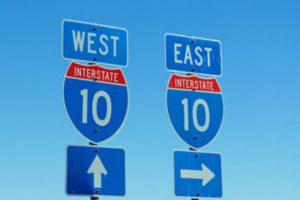
Standardized signage throughout the country was also part of the plan, with red, white, and blue shield signs for Interstate numbers and green with white lettering for exit signs.
The National Interstate Highway is now 47,856 miles and is an integrated network of roads and highways numbered within a nationwide grid across the United States. All but four State capitals are directly served by the Interstate System. Those not directly served are Juneau, AK; Dover, DE; Jefferson City, MO; and Pierre, SD.
Here Are Some More Interesting Facts About Our National Interstate Highways:
- Major Interstate routes are designated by one- or two-digit numbers. Routes with odd numbers run north and south, while even numbered run east and west. For north-south routes, the lowest numbers begin in the west, while the lowest numbered east-west routes are in the south.
- Connecting Interstate routes and full or partial circumferential beltways around or within urban areas carry a three-digit number. These routes are designated with the number of the main route and an even-numbered prefix. Supplemental radial and spur routes, connecting with the main route at one end, also carry a three-digit number, using the number of the main route with an odd-number prefix. To prevent duplication within a State, a progression of prefixes is used for the three-digit numbers. For example, if I-80 runs through three cities in a State, circumferential routes around these cities would be numbered as I-280, I-480, and I-680.
- The oldest Interstate segments actually predate the establishment of the Interstate system. Early examples include a portion of the Grand Central Parkway in Queens, New York, was opened to traffic in July 1936 and later was incorporated into the Interstate System as I-278. The Pennsylvania Turnpike between Irwin (southeast of Pittsburgh) and Carlisle (west of Harrisburg) was officially opened in October 1940 and is now designated as I-76 and I-70. Other freeways and toll roads were incorporated into the System rather than build new competing Interstate routes.
- The States typically use one of two methods of numbering the Interstate interchange exits.
- The Consecutive numbering system — Starting at the most westerly or southerly point on each Interstate route, interchanges are numbered consecutively. Thus the first interchange becomes Interchange #1. Each succeeding interchange is numbered consecutively as #2, 3, 4, etc.
- The Milepost numbering system — All Interstate routes are mileposted beginning at the most westerly or southerly point. The beginning point is milepost ‘0’. If the first interchange on the route is located between milepost 4.0 and 5.0, it is numbered as Interchange #4. The next interchange, if located at milepost 8.7, would be numbered as Interchange #8, etc. With this system the motorist can easily determine the location and distance to a desired interchange.
- The longest Interstate is I-90 from Seattle, Washington to Boston, Massachusetts and is 3,085.27 miles. For us in Arizona, our longest interstate highway is I-10, goes coast to coast running from Los Angeles, California to Jacksonville, Florida and is 2,459.96 miles long.
- The shortest is I-97, Annapolis to Baltimore, Maryland which measures 17.5 miles. In Arizona, the shortest is I-19 which connects Tucson to Nogales and stretches 63.75 miles.
- The States own and operate the Interstate Highways, and they set the speed limits for their state.
- There are1,214 rest areas along the interstates.
Does it make you want to get out on those long stretches of highway and take a road trip somewhere? Now you know a little more about our National Interstate System. Enjoy!